These plan sets are meant as templates that other neighborhoods and communities can freely use or build upon/evolve.
We got pre-approval from the City of Tucson for all these by getting well over the 60% minimum of neighbors to sign on their approval to petitions generated by the city’s neighborhood traffic management program, then shared by neighbors that went knocking door to door with the petitions and more information on the proposed strategies.
All water-harvesting chicanes and round-a-bouts utilize vegetation native to the Tucson Basin, as such native plants are the best adapted to our local climate, soils, and wildlife; and can thrive solely on passively-harvested rain and stormwater once established. (It takes one to three years of supplemental irrigation to get the plantings established).
Brad Lancaster did the design. Logan Byers and Oscar Rodriguez Ponce of Tucson Clean & Beautiful did the AutoCAD drawings.
Water-harvesting traffic-calming chicane plan set for a neighborhood intersection where two bicycle boulevards intersect, in a way that makes on-street parallel parking safer
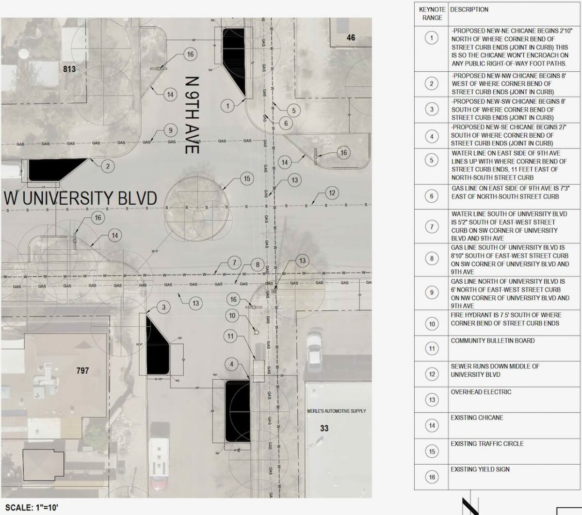
The plan set for the intersection of 9th Avenue and University Blvd. in 2025, added four chicanes to the four that had be installed in 2010. All the chicanes narrow the street at the entry and exit of the intersection, while directing traffic out of the parking lane, and into the driving lane. We have not had a hit and run on a parked car since this installation. This has increased the amount of cars that now park on the street, thereby further narrowing the street (and slowing traffic) with the parked cars.
One of the chicanes includes public seating beneath large native shade trees beside a community bulletin board.
For more on the installation see here.
For the plan set see HERE.
Water-harvesting traffic-calming chicane plan set integrated with angled back-in parking (safer for bicyclists and pedestrians) on both sides of the street
This excessively wide street has long experienced dangerous speeding traffic cutting through our neighborhood, and collisions with parked cars – especially when traffic backs up on Stone Ave to the east or Main Ave to the west (where there is a railroad track crossing often blocked by long passing trains).
The plan set for 4th Street between Perry Avenue and 9th Avenue narrows the street from both sides with angled-back in parking, which is much safer for pedestrians and cyclists than angled forward-in parking.
Water-harvesting traffic-calming chicanes book-end the angled back-in parking to protect the parked cars, and to grow native food forests that will help shade parked cars, pedestrians, and cyclists.
For the plan set see HERE.
Water-harvesting traffic-calming chicane plan set integrated with angled-back-in parking (safer for bicyclists and pedestrians) on one side of the street.
This excessively block of street has long experienced dangerous speeding traffic cutting through our neighborhood – especially when traffic backs up on Stone Ave to the east or Main Ave to the west (where there is a railroad track crossing often blocked by long passing trains).
The plan set for University Blvd between 9th Avenue and Ash Avenue narrows the street from just the north residential side (the south side is commercial with an auto parts store & warehouse) with angled-back in parking, which is much safer for pedestrians and cyclists than angled forward-in parking.
Water-harvesting traffic-calming chicanes book-end the angled back-in parking to protect the parked cars, and to grow native food forests that will help shade parked cars, pedestrians, and cyclists.
For the plan set see HERE.
Painted traffic-calming chicane plan set where water-harvesting chicanes are not possible due to underground water lines
This plan set is for the SE corner of 9th Ave and University Blvd where there are underground water lines in the area where we originally wanted water-harvesting chicanes (as they allow us to grow multi-use plants/shade/beauty, reduce flooding, recharge our aquifer, and more).
But as the water lines make it impossible to dig below the level of the asphalt (and we also could not block and existing fire hydrant), we’ll just have painted chicanes with vertical markers and 8-inch ceramic half-dome pavement markers with reflectors delineating the boundary of the painted chicanes.
A local artist will direct the painting of street murals within the chicane boundaries.
For the plan set see HERE.

Major funding for this project is provided by the Arizona Department of Forestry and Fire Management and USDA Forest Service. These institutions are equal opportunity providers and employers.”